Mapping Reality: Ideology and Ethics in Cartography

Amy Brabec
If one were to ask an individual in front of a map what they are observing, they would likely respond that they are looking at the world. The omnipresence of maps has allowed them to acquire a nearly transcendental status and this prevents most individuals from questioning what exactly maps represent. Careful analysis reveals that maps are not natural nor are they perfect reflections of the world; maps are theory and maps are propaganda. The maps that communities have access to have the power to shape the way that they conceptualize the actual space and land of earth. Since maps influence beliefs about world territory, it is important to regulate cartography with some ethical notions. These ethics, along with consciousness of the ideology that underlies traditional maps, have inspired creative thinkers to put forth alternative world maps. Just like their predecessors, these maps are imperfect social constructions. However, non-traditional maps have greater potential to challenge unfairly Western-centric perspectives and promote global responsibility beyond the limits of the sovereign state. This paper seeks to assess the validity and usefulness of revisionist maps in light of the Poststructuralist concept of moral cartography.
To begin, maps are analogous to theory because much of the language used in the study of international relations theory can also be applied to maps. Maps in a broad sense seem to play a natural role in the field of political theory. For example, it is common to hear discourse about mapping out theories in relation to one another or placing one’s political leanings on some sort of mythical chart of potential viewpoints. Maps can act as general intellectual metaphors through aiding in the arrangement of isolated events into relations of coherence and thus ideological maps make knowledge transmittable (Dodge et al. eds. 2011). The adoption of cartographical language in international relations theory shows that the spatial dimension helps in explaining and comparing theories. Similarly, terminology used and questions considered in the study of international relations can contribute to a deeper understanding of maps. A central concern in IR theory which can also be applied to maps is the question of what exactly theory is and what it does. Positive theory, or theory that provides descriptive, factual explanations, corresponds with the objective depictions of the world that most people expect from maps (Dunne et al. 2013, 410). However, most political theories attempt to go beyond merely providing an accurate description of events. Constitutive theory examines the makeup of various entities and asserts that the ideas people hold actually constitute the social world (Dunne et al. 2013, 411). When extrapolated to the realm of maps, constitutive theory explains how some individuals very literally construct their world based upon the ideas contained in maps. Another response to the question of what theory is and does is the understanding of theory as a lens through which the world is viewed. Dunne et al. describe the lens metaphor as follows: “If we use one lens, we will see the world in one particular way, perhaps with certain elements highlighted and others hidden from view, or placed on the margins” (2013, 412). Maps too can be seen as lenses because they position certain privileged areas in the center and, as a result, visually establish a periphery. Clearly maps can be analyzed in relation to the responses to the question of what theory is and does. Going deeper into the matter, it is possible to say that maps themselves are theory. If theory’s purpose is to make the world more understandable, as Viotti and Kauppi state that it is, then maps are indeed theory (Dunne et al. 2013, 408). Furthermore, maps are decidedly more accessible and less exclusive than the theories of academia because individuals of nearly any level of education can interpret their visual format.
While it is true that maps are a form of political theory that nearly anyone can understand, it cannot be said that maps are free from bias and consequently they must be treated with caution. It is important to establish that, in addition to being a form of theory, maps are also a form of propaganda. The first step in realizing that maps are propaganda is to understand that they are not natural. As Alfred Korzybski once stated, “a map is not the territory it represents;” it is necessary to separate the reality of land on earth from the social construct of maps (quoted in Crampton 2001, 696). Although humans do intuitively conceptualize their world spatially, maps are unnatural constructions that recreate space in accordance with specific political and economic aims. Map-making became systematized with the rise of empires and private land ownership. One of the first uses of geometrical surveying in mapmaking was by the sixteenth century nobles of Venice who sought to mark off all land that could be exploited for profit. Other early modern maps were used for plotting military campaigns, administering provinces, and making sense of overseas colonies (Dalton 2012, 60-61). These historical maps served particular purposes and therefore their representations of space are skewed in favor of the powers by which they were commissioned. Today maps are such common and unquestioned objects that they make the abstract realities they represent, such as international borders, seem as if they were external, immutable truths. All maps reflect countless decisions to include or exclude both physical and geopolitical details, though a good map convinces viewers that its arbitrary representation of the world corresponds with global realities (Chatting 2011, 11). Maps are still instruments for political purposes such as waging war, assessing taxes, and making use of resources (Wood 1992, 43). Monmonier warns that politically motivated maps are necessarily selective and partial and that often the elements of propaganda within maps are cleverly concealed by their appealing and credible design. Therefore it is critical to practice “informed skepticism” towards maps, on both visual and mental levels (Monmonier 1995, 298).
The maps to which people are exposed greatly impact the way in which they perceive global territory. A 1986 study in which first-year university students from around the world were asked to sketch a world map from memory produced troubling results. Predictably, it was a general trend to draw one’s home continent in an exaggerated size and with greater detail than the rest of the map. Another outcome was that the majority of those surveyed inflated the size of Europe and diminished the size of Africa. This trend was consistent even when the test was administered to Africans (Saarien et al. 1996, 37). The students tested likely were most familiar with the traditional map projections, like the Mercator map, that magnify the Global North. As this test indicates, biased maps impact not only the way in which powerful countries view marginalized countries, but also the global periphery’s own geographical self-perception. The Mercator map, which is widely considered a standard map, distorts the size of the northern continents and gives Europe a central position. This map dates back more than 400 years to the age of European navigation and colonization (Wood and Fels 1992, 60). Considering the historical context in which it was created, it should be no surprise that the Mercator map has been associated with neocolonialism, Eurocentrism, and white supremacism (Klinghoffer 2006, 121). How to size the continents in relation to one another and which continent to depict as the center of the world are not random decisions. In the case of the Mercator map, the disparities regarding the relative size of the continents can be explained with the argument that the perspective used is the most practical one for seafaring and therefore the map doesn’t contain intentional alterations for ideological reasons (Klinghoffer 2006, 121). The problem with the Mercator map is that it continues to be widely used long after the seafaring age. Whether or not this was intended as a tool for asserting European domination, it has become one as it still impacts the way people envision the world’s land.
Since maps are objects of propaganda and they have influence over our perception of land, it follows that there should be a system of ethics to attempt to regulate cartography. The problem with evaluating the ethics of mapmaking is that the misrepresentations and inequalities in maps are subtle and are often cleverly hidden by appealing design techniques (Monmonier 1995, 297). Cases of knowingly falsified maps, like the intentionally deceptive maps from formerly communist Eastern European states, are easy to classify as unethical. Michael Peterson makes a broader statement and says that the central values in cartography are accuracy and communication (Peterson 1999, 5). Using Peterson’s criteria, maps that serve specific ideological aims can be called doubly unethical because they distort the actual appearance of the world and they do not communicate their intentions in a direct way. Maps can also violate ethical principles when their makers put economic gain above the value of accuracy. Craig Dalton warns about this tendency in his discussion about how some modern-day maps have turned from tools of state ideology into reflections of the interests of businesses like Google (2012, 60). A theory of ethics for maps that varies substantially from Peterson’s is the one elaborated by McHaffie, Andrews, and Dobson along with two anonymous United States government employees. In 1990, this group listed product quality management, conflicts of interest, and map plagiarism as issues relevant in cartography. They also claim that map-related values cannot be divorced from the general ethical climate of the society that commissions the maps (Peterson 1999, 5). This group’s inclusion of quality control equates maps with other mere commodities, which gives a decidedly commercial tone to cartography. Also, it seems absurd to bring copyright issues into a field that attempts to recreate the external world, but this just shows that McHaffie et al. see cartography more as a trade than as a way of sharing knowledge. Identifying a map as one’s intellectual property mirrors on a small scale the tendency to assert power by claiming and exploiting land. Perhaps the most interesting statement from McHaffie et al. is that the values of maps cannot be separated from the values of the society commissioning the map. The flaw in this argument is that maps actually condition the society that views them and so, unless critical reflection takes place, people are likely to commission representations of the world that resemble the maps most familiar to them.
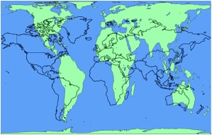
Monmier took his ethical concerns about maps and formulated them into a more concrete call to action. He asserted that each map is one of countless potential maps that could have been created from the same data (Wood and Fels 1992, 71). The final product of the mapmaking process is subjective and incomplete and therefore Monmier warns against the “Single Map Solution.” No one map is sufficient for understanding world geography because ulterior motives could have caused deviations from reality in support of the cartographer’s preferences and because the cartographer may not have considered more adequate alternative designs (Peterson 1999, 5). If we take heed to Monmier’s warning against the “Single Map Solution,” the next ethical dilemma is that of deciding which alternative maps we should consider. While there have been many Eurocentric, north-favoring maps following the Mercator projection, including ones that correct some of Mercator’s proportional errors, the ideological messages of these maps are similar so it is beneficial to consider more radically different maps. One such map is Arno Peters’ equal-area projection map. Before developing his controversial map, Peters wrote a dissertation about film as propaganda, proving that he was familiar with non-academic forms of theory. Peters aimed to create a “counter-cartography based on egalitarian principles” that highlights the gap between rich and poor and challenges European dominance (Klinghoffer 2006, 121). The figure below, in which the Peters’ map projection appears in green overlaying a blue Mercator map, dramatically shows the contrast between the two projections. Critics have denounced Peters’ project as propaganda, though Peters himself probably would not have considered this much of an insult since he recognized the pervasiveness and multiplicity of forms of propaganda (Wood and Fels 1992, 60).
If one were to ask an individual in front of a map what they are observing, they would likely respond that they are looking at the world. The omnipresence of maps has allowed them to acquire a nearly transcendental status and this prevents most individuals from questioning what exactly maps represent. Careful analysis reveals that maps are not natural nor are they perfect reflections of the world; maps are theory and maps are propaganda. The maps that communities have access to have the power to shape the way that they conceptualize the actual space and land of earth. Since maps influence beliefs about world territory, it is important to regulate cartography with some ethical notions. These ethics, along with consciousness of the ideology that underlies traditional maps, have inspired creative thinkers to put forth alternative world maps. Just like their predecessors, these maps are imperfect social constructions. However, non-traditional maps have greater potential to challenge unfairly Western-centric perspectives and promote global responsibility beyond the limits of the sovereign state. This paper seeks to assess the validity and usefulness of revisionist maps in light of the Poststructuralist concept of moral cartography.
To begin, maps are analogous to theory because much of the language used in the study of international relations theory can also be applied to maps. Maps in a broad sense seem to play a natural role in the field of political theory. For example, it is common to hear discourse about mapping out theories in relation to one another or placing one’s political leanings on some sort of mythical chart of potential viewpoints. Maps can act as general intellectual metaphors through aiding in the arrangement of isolated events into relations of coherence and thus ideological maps make knowledge transmittable (Dodge et al. eds. 2011). The adoption of cartographical language in international relations theory shows that the spatial dimension helps in explaining and comparing theories. Similarly, terminology used and questions considered in the study of international relations can contribute to a deeper understanding of maps. A central concern in IR theory which can also be applied to maps is the question of what exactly theory is and what it does. Positive theory, or theory that provides descriptive, factual explanations, corresponds with the objective depictions of the world that most people expect from maps (Dunne et al. 2013, 410). However, most political theories attempt to go beyond merely providing an accurate description of events. Constitutive theory examines the makeup of various entities and asserts that the ideas people hold actually constitute the social world (Dunne et al. 2013, 411). When extrapolated to the realm of maps, constitutive theory explains how some individuals very literally construct their world based upon the ideas contained in maps. Another response to the question of what theory is and does is the understanding of theory as a lens through which the world is viewed. Dunne et al. describe the lens metaphor as follows: “If we use one lens, we will see the world in one particular way, perhaps with certain elements highlighted and others hidden from view, or placed on the margins” (2013, 412). Maps too can be seen as lenses because they position certain privileged areas in the center and, as a result, visually establish a periphery. Clearly maps can be analyzed in relation to the responses to the question of what theory is and does. Going deeper into the matter, it is possible to say that maps themselves are theory. If theory’s purpose is to make the world more understandable, as Viotti and Kauppi state that it is, then maps are indeed theory (Dunne et al. 2013, 408). Furthermore, maps are decidedly more accessible and less exclusive than the theories of academia because individuals of nearly any level of education can interpret their visual format.
While it is true that maps are a form of political theory that nearly anyone can understand, it cannot be said that maps are free from bias and consequently they must be treated with caution. It is important to establish that, in addition to being a form of theory, maps are also a form of propaganda. The first step in realizing that maps are propaganda is to understand that they are not natural. As Alfred Korzybski once stated, “a map is not the territory it represents;” it is necessary to separate the reality of land on earth from the social construct of maps (quoted in Crampton 2001, 696). Although humans do intuitively conceptualize their world spatially, maps are unnatural constructions that recreate space in accordance with specific political and economic aims. Map-making became systematized with the rise of empires and private land ownership. One of the first uses of geometrical surveying in mapmaking was by the sixteenth century nobles of Venice who sought to mark off all land that could be exploited for profit. Other early modern maps were used for plotting military campaigns, administering provinces, and making sense of overseas colonies (Dalton 2012, 60-61). These historical maps served particular purposes and therefore their representations of space are skewed in favor of the powers by which they were commissioned. Today maps are such common and unquestioned objects that they make the abstract realities they represent, such as international borders, seem as if they were external, immutable truths. All maps reflect countless decisions to include or exclude both physical and geopolitical details, though a good map convinces viewers that its arbitrary representation of the world corresponds with global realities (Chatting 2011, 11). Maps are still instruments for political purposes such as waging war, assessing taxes, and making use of resources (Wood 1992, 43). Monmonier warns that politically motivated maps are necessarily selective and partial and that often the elements of propaganda within maps are cleverly concealed by their appealing and credible design. Therefore it is critical to practice “informed skepticism” towards maps, on both visual and mental levels (Monmonier 1995, 298).
The maps to which people are exposed greatly impact the way in which they perceive global territory. A 1986 study in which first-year university students from around the world were asked to sketch a world map from memory produced troubling results. Predictably, it was a general trend to draw one’s home continent in an exaggerated size and with greater detail than the rest of the map. Another outcome was that the majority of those surveyed inflated the size of Europe and diminished the size of Africa. This trend was consistent even when the test was administered to Africans (Saarien et al. 1996, 37). The students tested likely were most familiar with the traditional map projections, like the Mercator map, that magnify the Global North. As this test indicates, biased maps impact not only the way in which powerful countries view marginalized countries, but also the global periphery’s own geographical self-perception. The Mercator map, which is widely considered a standard map, distorts the size of the northern continents and gives Europe a central position. This map dates back more than 400 years to the age of European navigation and colonization (Wood and Fels 1992, 60). Considering the historical context in which it was created, it should be no surprise that the Mercator map has been associated with neocolonialism, Eurocentrism, and white supremacism (Klinghoffer 2006, 121). How to size the continents in relation to one another and which continent to depict as the center of the world are not random decisions. In the case of the Mercator map, the disparities regarding the relative size of the continents can be explained with the argument that the perspective used is the most practical one for seafaring and therefore the map doesn’t contain intentional alterations for ideological reasons (Klinghoffer 2006, 121). The problem with the Mercator map is that it continues to be widely used long after the seafaring age. Whether or not this was intended as a tool for asserting European domination, it has become one as it still impacts the way people envision the world’s land.
Since maps are objects of propaganda and they have influence over our perception of land, it follows that there should be a system of ethics to attempt to regulate cartography. The problem with evaluating the ethics of mapmaking is that the misrepresentations and inequalities in maps are subtle and are often cleverly hidden by appealing design techniques (Monmonier 1995, 297). Cases of knowingly falsified maps, like the intentionally deceptive maps from formerly communist Eastern European states, are easy to classify as unethical. Michael Peterson makes a broader statement and says that the central values in cartography are accuracy and communication (Peterson 1999, 5). Using Peterson’s criteria, maps that serve specific ideological aims can be called doubly unethical because they distort the actual appearance of the world and they do not communicate their intentions in a direct way. Maps can also violate ethical principles when their makers put economic gain above the value of accuracy. Craig Dalton warns about this tendency in his discussion about how some modern-day maps have turned from tools of state ideology into reflections of the interests of businesses like Google (2012, 60). A theory of ethics for maps that varies substantially from Peterson’s is the one elaborated by McHaffie, Andrews, and Dobson along with two anonymous United States government employees. In 1990, this group listed product quality management, conflicts of interest, and map plagiarism as issues relevant in cartography. They also claim that map-related values cannot be divorced from the general ethical climate of the society that commissions the maps (Peterson 1999, 5). This group’s inclusion of quality control equates maps with other mere commodities, which gives a decidedly commercial tone to cartography. Also, it seems absurd to bring copyright issues into a field that attempts to recreate the external world, but this just shows that McHaffie et al. see cartography more as a trade than as a way of sharing knowledge. Identifying a map as one’s intellectual property mirrors on a small scale the tendency to assert power by claiming and exploiting land. Perhaps the most interesting statement from McHaffie et al. is that the values of maps cannot be separated from the values of the society commissioning the map. The flaw in this argument is that maps actually condition the society that views them and so, unless critical reflection takes place, people are likely to commission representations of the world that resemble the maps most familiar to them.
Monmier took his ethical concerns about maps and formulated them into a more concrete call to action. He asserted that each map is one of countless potential maps that could have been created from the same data (Wood and Fels 1992, 71). The final product of the mapmaking process is subjective and incomplete and therefore Monmier warns against the “Single Map Solution.” No one map is sufficient for understanding world geography because ulterior motives could have caused deviations from reality in support of the cartographer’s preferences and because the cartographer may not have considered more adequate alternative designs (Peterson 1999, 5). If we take heed to Monmier’s warning against the “Single Map Solution,” the next ethical dilemma is that of deciding which alternative maps we should consider. While there have been many Eurocentric, north-favoring maps following the Mercator projection, including ones that correct some of Mercator’s proportional errors, the ideological messages of these maps are similar so it is beneficial to consider more radically different maps. One such map is Arno Peters’ equal-area projection map. Before developing his controversial map, Peters wrote a dissertation about film as propaganda, proving that he was familiar with non-academic forms of theory. Peters aimed to create a “counter-cartography based on egalitarian principles” that highlights the gap between rich and poor and challenges European dominance (Klinghoffer 2006, 121). The figure below, in which the Peters’ map projection appears in green overlaying a blue Mercator map, dramatically shows the contrast between the two projections. Critics have denounced Peters’ project as propaganda, though Peters himself probably would not have considered this much of an insult since he recognized the pervasiveness and multiplicity of forms of propaganda (Wood and Fels 1992, 60).
http://piedtype.files.wordpress.com/2014/03/petersprojectionoverlay.jpg
A more valid critique of Peters’ projection is that it still positions Europe in the middle of the map. On top of the linguistic value of being called the center of world, the focus of a map is important because viewers naturally direct their attention to the center of the map due to a phenomenon that Jacob calls the ‘Omphalos (navel) syndrome.’ Maps with Europe at the center promote the notion that Europe represents the height of human civilization and development (Fotiadis 2009, 42). In 1979, Australian McArthur presented his Universal Corrective Map of the World in which south is at the top and, accordingly, Australia lies in the center. It appears that McArthur found his project amusing as he remarked that traditional maps provoke “down under” jokes, but thanks to his map Australia can claim its rightful place as “ruler of the universe” (Chatting 2011, 15). Humor aside, McArthur was correct in asserting that an inverted map makes the global south more visible while simultaneously stripping Europe and North America of their usual privileged position. The figurative meaning of turning one’s world upside-down in the sense of questioning everything that once seemed certain definitely applies to McArthur’s map. Fotiadis points out that the very fact that maps such as McArthur’s are described as upside-down reveals that traditional maps dominate our thoughts so profoundly that even though it can be argued that objectively there is no top or bottom to the planet, it simply seems wrong to place the south at the top of a map (2009, 41-42). J.B. Harley would commend equal-area projections and inverted maps as examples of ethical cartography because they foster connections between maps and social justice issues while promoting a vision of the world in which a responsible mapmaker would chose to live (Harley 2001, 207). For now alternative maps are judged against the standards of Eurocentric maps and they are yet to reach the level of accessibility and credibility that traditional maps enjoy. Peters and McArthur’s projects are by no means the only revisions of conventional maps, but they are notable examples that generated fruitful conversations about the ideology contained in maps.
Poststructuralism is a useful tool in considering the ethical elements of maps. In the 80s and early 90s scholars such as J.B. Harley worked to blend the realms of cartography and poststructuralist theory to better explain how maps transmit knowledge. Harley drew from Foucault’s work to develop the idea of maps as sites of power-knowledge (Crampton 2001, 692-694). Additional insight on how maps contribute to global power relations came from Shapiro, who emphasized cartography’s role in codifying and judging the “other.” The case of the world map being divided into the moral realms of the “Free World” and the “Soviet bloc” during the Cold War clearly illustrates how maps can be used to illustrate ideological us/ them dichotomies. Shapiro also mentions how maps normalize the unit of the nation-state and impose it upon the entirety of the world territory as the basic unit of government (Shapiro 2012, 9-10). Campbell and other ‘transversal’ thinkers consider the shortcomings of the current system of international relations in which national boundaries decide which entities are legitimate actors. Furthermore, Campbell noted that the emphasis on territorial boundaries produces a ‘moral cartography’ in which democracy and ethical responsibility are restricted to the limits of the sovereign state. Campbell’s hope was that through normalizing sources of identity besides state boundaries it would become easier to promote global, as opposed to bounded, ethics. Finally, poststructuralism identifies that borders are ambiguous historical products and therefore they do not deserve the transcendental status that many individuals subconsciously attribute to them (Devetak 205-208).
While the poststructuralist discussion about ‘moral cartography’ largely focuses on ideas held about geography rather than on maps as objects, it would be necessary to alter maps in order to achieve poststructuralist aims. Non-traditional maps that express a sense of ‘ethical cartography’ have more potential to help eradicate ‘moral cartography’ than do conventional maps. Maps such as those created by Peters and McArthur presently elicit reactions of surprise or confusion because they don’t match expectations about world maps. Thus, national boundaries automatically become secondary to reorienting oneself in light of the novel depiction of the world. Also, in the case of an inverted map viewers from the global north will visually perceive a role reversal with the marginalized south, a geographical realm often considered the “other.” Giving centrality to ignored groups could help further the cause of global justice, which Popke cites as a central aim of the collaboration between poststructuralist theory and human geography (2003, 298). Maps that downplay the role of borders through offering new perspectives on territory help to de-normalize bounded ethics. Just as people talk about the need to see situations from another point of view when considering matters of social inequality, it is important to have multiple maps to literally see varying perspectives of the world. Lastly, non-traditional maps do an excellent job of showing how borders are man-made and arbitrary because they challenge cartographical elements that once seemed natural. Realizing that Africa is actually much bigger than Alaska or that there is no objective up or down in the planet makes one wonder what other characteristics of maps reflect social conventions rather than reality.
In synthesis, maps must be understood both as theory and as propaganda. It is dangerous to assume that maps are wholly accurate or neutral chartings of earth’s territory because all maps are made by someone for some purpose. The ever-present Mercator map amplifies Europe and places it in the center of the world in both the literal and the ideological senses. The prominence of this map projection has influenced the way in which people from all continents perceive the relative size, and by extension power, of the landmasses. The field of cartography is not devoid of its ethical considerations, but cases like using maps to deliberately mislead citizens about national boundaries are much more clear-cut than the ethics of subtly promoting a Western-centric worldview and thus the ideological underpinnings of maps often go undetected. Poststructuralism has contributed significantly to the conversation about the relationship between territorial boundaries and ethical responsibility by describing the detrimental effects of ‘moral cartography’ which limits the sphere of moral accountability to the confines of the sovereign state (Devetak 2009, 208). Conventional maps undoubtedly enable moral cartography because they make borders seem like part of the natural order. Various individuals who recognized the injustices of traditional maps have created alternative presentations of the world map that make use of different projections, place continents other than Europe at the center, or even invert the classical notions of north and south. These revisionist maps are more adequate for promoting ethical actions beyond the nation-state because they remove elements of Eurocentric privilege and encourage onlookers to see the interconnectedness of the world in new ways. Non-traditional maps visually put the regions of the world on a more equal level and perhaps if these maps were more widely diffused they would start to cultivate mindsets that reflect global equality. However, Mercator maps and other similar projections still predominate in textbooks, classrooms, news broadcasts, and countless other places. Alternative maps are too often regarded as novelties or even socially critical art. Adopting non-traditional maps would be a positive step for promoting global responsibility, but since certain powerful individuals like to believe that the Mercator map accurately represents the world, it is unlikely that this shift will take place in the near future.
Bibliography
Campbell, David and Michael J. Shapiro, eds. Moral Spaces: Rethinking Ethics and World Politics. Minneapolis: University of Minnesota Press, 1999.
Chatting, David John. “Mapping Horizons: the common sense of here.” PhD. diss., The Royal College of Art, 2011.
Crampton, Jeremy W. “Maps as Social Constructions: Power, Communication, and Visualization.” Progress in Human Geography 25 (2001) pp. 235-252, accessed 2 April, 2014.
Dalton, Craig M. “Mashing up Maps: Google Geo Services and the Geography of Ubiquity.” PhD diss., University of North Carolina at Chapel Hill, 2012.
Devetak, Richard. “Post-structuralism.” In Theories of International Relations, Scott Burchill et. al., 183-211. Houndmills: Palgrave Macmillan, 2009.
Dodge, Martin, Rob Kitchin, and Chris Perkins, eds. The Map Reader: Theories of Mapping Practice and Cartographic Representation. Hoboken: John Wiley & Sons, 2011.
Dunne, Tim, Lene Hanson and Colin Wight. “The end of International Relations theory?” European Journal of International Relations 19 (2013) pp. 405-425.
Fotiadis, Piers. “The Strange Power of Maps: How maps work politically and influence of understanding of the world.” MSc diss., University of Bristol 2009.
Harley, J.B. The New Nature of Maps: Essays in the History of Cartography. Baltimore: The Johns Hopkins University Press, 2001.
Klinghoffer, Arthur Jay. The Power of Projections: How Maps Reflect Global Politics and History. Westport, CT: Praeger Publishers, 2006.
Monmonier, Mark S. Drawing the Line: Tales of Maps and Cartocontroversy. New York: Henry Holt and Company, Inc., 1995.
Peterson, Michael P., “Maps on Stone: the Web and Ethics of Cartography,” Journal of the North American Cartographic Society, Number 34 (1999) pp. 5-8, accessed 2 April, 2014.
Popke, Jeffrey E. “Poststructuralist ethics: subjectivity, responsibility, and the space of community.” Progress in Human Geography 27,3 (2003) pp. 298-316, accessed 4 April, 2014.
Quino. Mafalda comic on inverted maps. 1996. Web. Accessed 4 May, 2014.
Saarinen, Thomas F., Michael Parton, and Roy Billberg. “Relative Size of Continents on World Sketch Maps.” University of Arizona, 1996.
Shapiro, Michael J. Michael J. Shapiro: Discourse, Culture, Violence, eds. Terrell Carver and Samuel A. Chambers. New York: Routledge, 2012.
Wood, Denis and John Fels. The Power of Maps. New York: The Guilford Press, 1992.
